Leafletで地図上に二点間の経路を線引してみよう
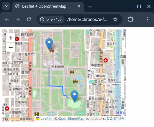
Leafletで位置情報をオブジェクトの形式で持つように変えてみようとLeafletで地図上に線を引いてみようの内容を組み合わせて、二点間の移動経路を表示してみよう。
https://github.com/inunosinsi/Leaflet_OpenStreetMap_Sample/blob/main/9.htmlで作成したコードにコードを改修していきます。
let lines = [
	{
		"type": "LineString",
		"coordinates": [
			[135.76198, 35.02320],
			[135.76198, 35.02116],
			[135.76383, 35.02111],
			[135.76394, 35.02013],
			[135.76426, 35.02009],
			[135.76464, 35.01976]
		]
	}
];

L.geoJSON(lines).addTo(map);
を
let objects = [
	{
		"type" : "Feature",
		"properties" : {
			"name" : "京都御苑",
			"url" : "https://www.openstreetmap.org/#map=17/"+lat+"/"+lng
		},
		"geometry" :  {
			"type": "Point",
			"coordinates" : [lng, lat]	//注意:緯度経度の渡し方が逆になる
		}
	},
	{
		"type": "LineString",
		"coordinates": [
			[135.76198, 35.02320],
			[135.76198, 35.02116],
			[135.76383, 35.02111],
			[135.76394, 35.02013],
			[135.76426, 35.02009],
			[135.76464, 35.01976]
		]
	},
	{
		"type" : "Feature",
		"properties" : {
			"name" : "富小路広場",
			"url" : "https://www.openstreetmap.org/#map=17/35.019229/135.765492"
		},
		"geometry" :  {
			"type": "Point",
			"coordinates" : [135.765492, 35.019229]
		}
	}
];

L.geoJSON(objects).addTo(map);
※今回は線(LineString)と地物(Feature)を合わせた配列になりますので、変数名をlinesからobjectsに変更しています。
位置情報の配列を作るに当たって、ピンを立てる為のFeatureと線を引く為のLineStringのオブジェクトを両方含めています。
地物(Feature)の場合は、geometryの値を持ち、その中でtypeをPointで指定したオブジェクト内でcoordinates(座標)を持つ事が重要で、線(LineString)の場合は、typeと同階層のプロパティでcoordinatesを持つことが重要になります。
これらの記述ルールはUsing GeoJSON with Leaflet - Leaflet - a JavaScript library for interactive mapsに記載されている内容を参考にしましょう。
今回のコードはhttps://github.com/inunosinsi/Leaflet_OpenStreetMap_Sample/blob/main/11.htmlになります。
OpenStreetMapとLeafletの作品:土を理解する為の探求マップ
inunosinsiというアカウントで、オープンストリートマップに参加しています。
https://www.openstreetmap.org/user/inunosinsi
inunosinsiというアカウントで、オープンストリートマップに参加しています。
https://www.openstreetmap.org/user/inunosinsi
同じカテゴリーの記事
- クロスティーニに最新版のNode.jsをインストールする
- Node.jsで簡易的なサーバを立ち上げる
- クロームブックのマインクラフトでmcws.jsを使ってみる
- Blocklyを試してみよう
- Blocklyでコードを実行してみよう
- Blocklyでブロックを日本語表記にしてみる
- Blocklyのブロック一覧
- Blocklyで初期値付きのブロックを設置する
- Blocklyのカスタムブロックを作ってみる
- Blocklyでツールボックスのブロックをカテゴリ分けしてみる
- Blocklyで繋がっていないブロックを実行の対象外にする
- Blocklyでずっとブロックを作成する
- BlocklyのカスタムブロックをJS-Interpreterで実行できるようにする
- Blocklyで変数を利用できるようにする
- Blocklyで関数を利用できるようにする
- Electronを試してみよう
- Electronのプロセス間通信について
- Electronのプロセス間通信について2
- Electronのアプリのパッケージ
- LeafletでOpenStreetMapの地図を出力してみよう
- Leafletで任意の地点でピン(マーカー)を立ててみよう
- Leafletでピンをクリックするとポップアップが表示されるようにしてみよう
- Leafletでピンをクリックすると任意のサイトに移動するようにしてみよう
- Leafletで位置情報をオブジェクトの形式で持つように変えてみよう
- Leafletで地図上に線を引いてみよう
- Leafletで地図上に二点間の経路を線引してみよう
- Leafletでカテゴリ分けをしてみよう
他のカテゴリー
マインクラフト用ビジュアルエディタを開発しています。
詳しくはinunosinsi/mcws_blockly - githubをご覧ください。