Leafletでカテゴリ分けをしてみよう
オブジェクト形式で複数の地物(feature)の情報をカテゴリ分けし、任意のカテゴリの地物のみピンを立ててみます。
今回の内容はLeafletで位置情報をオブジェクトの形式で持つように変えてみようのhttps://github.com/inunosinsi/Leaflet_OpenStreetMap_Sample/blob/main/6.htmlのコードを改修します。
はじめに、下記のように地物をたくさん登録します。
let features = [
	{
		"type" : "Feature",
		"properties" : {
			"name" : "上賀茂神社",
			"category" : "shrine"
		},
		"geometry" :  {
			"type": "Point",
			"coordinates" : [135.75224, 35.06048]
		}
	},
	{
		"type" : "Feature",
		"properties" : {
			"name" : "松尾大社",
			"category" : "shrine"
		},
		"geometry" :  {
			"type": "Point",
			"coordinates" : [135.685283, 35.000186]
		}
	},
	{
		"type" : "Feature",
		"properties" : {
			"name" : "八坂神社",
			"category" : "shrine"
		},
		"geometry" :  {
			"type": "Point",
			"coordinates" : [135.778254, 35.003608]
		}
	},
	{
		"type" : "Feature",
		"properties" : {
			"name" : "城南宮",
			"category" : "shrine"
		},
		"geometry" :  {
			"type": "Point",
			"coordinates" : [135.746952, 34.950646]
		}
	},
	{
		"type" : "Feature",
		"properties" : {
			"name" : "二条城",
			"category" : "castle"
		},
		"geometry" :  {
			"type": "Point",
			"coordinates" : [135.747795, 35.014135]
		}
	},
	{
		"type" : "Feature",
		"properties" : {
			"name" : "金閣寺",
			"category" : "temple"
		},
		"geometry" :  {
			"type": "Point",
			"coordinates" : [135.728440, 35.039529]
		}
	},
	{
		"type" : "Feature",
		"properties" : {
			"name" : "銀閣寺",
			"category" : "temple"
		},
		"geometry" :  {
			"type": "Point",
			"coordinates" : [135.798032, 35.026549]
		}
	}
];
地物を登録する際にpropertiesでcategoryの値を追加しておきます。
今回はshirine(神社)、castle(城)とtemple(寺)の地物を追加しています。
続いて、
L.geoJSON(features).addTo(map);
を
L.geoJSON(features, {
	filter: function(feature, layer) {
		switch(feature.properties.category){
			case "shrine":
				return true;
			default:
				return false;
		}
	}
}).addTo(map);
に書き換えます。
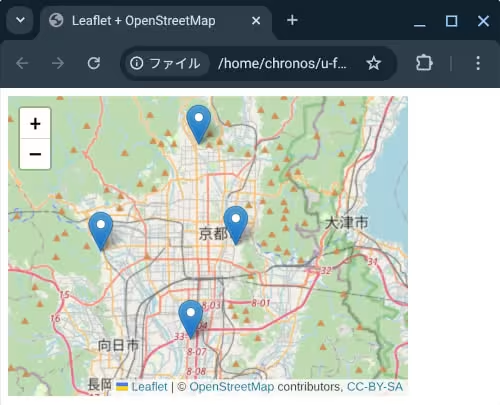
コードを変更した後、ファイルをクリックしてブラウザ上で実行してみますと、shrine(神社)の地物のみピンが立ちます。
L.geoJSONの第一引数のオブジェクトで、filterで無名関数を指定すると、各地物のオブジェクトを順番に確認します。
無名関数内でtrue(真)を返すとピンが立ち、false(偽)を返すとピンは立ちません。
if文で地物毎のカテゴリ(category)を確認し、表示したいカテゴリの地物のみ、trueを返すように書くことで、任意の地物のみのピンを立てることができます。
今回のコードはhttps://github.com/inunosinsi/Leaflet_OpenStreetMap_Sample/blob/main/12.html
OpenStreetMapとLeafletの作品:土を理解する為の探求マップ
inunosinsiというアカウントで、オープンストリートマップに参加しています。
https://www.openstreetmap.org/user/inunosinsi
inunosinsiというアカウントで、オープンストリートマップに参加しています。
https://www.openstreetmap.org/user/inunosinsi
同じカテゴリーの記事
- クロスティーニに最新版のNode.jsをインストールする
- Node.jsで簡易的なサーバを立ち上げる
- クロームブックのマインクラフトでmcws.jsを使ってみる
- Blocklyを試してみよう
- Blocklyでコードを実行してみよう
- Blocklyでブロックを日本語表記にしてみる
- Blocklyのブロック一覧
- Blocklyで初期値付きのブロックを設置する
- Blocklyのカスタムブロックを作ってみる
- Blocklyでツールボックスのブロックをカテゴリ分けしてみる
- Blocklyで繋がっていないブロックを実行の対象外にする
- Blocklyでずっとブロックを作成する
- BlocklyのカスタムブロックをJS-Interpreterで実行できるようにする
- Blocklyで変数を利用できるようにする
- Blocklyで関数を利用できるようにする
- Electronを試してみよう
- Electronのプロセス間通信について
- Electronのプロセス間通信について2
- Electronのアプリのパッケージ
- LeafletでOpenStreetMapの地図を出力してみよう
- Leafletで任意の地点でピン(マーカー)を立ててみよう
- Leafletでピンをクリックするとポップアップが表示されるようにしてみよう
- Leafletでピンをクリックすると任意のサイトに移動するようにしてみよう
- Leafletで位置情報をオブジェクトの形式で持つように変えてみよう
- Leafletで地図上に線を引いてみよう
- Leafletで地図上に二点間の経路を線引してみよう
- Leafletでカテゴリ分けをしてみよう
他のカテゴリー
マインクラフト用ビジュアルエディタを開発しています。
詳しくはinunosinsi/mcws_blockly - githubをご覧ください。